
Commons:Graphic Lab/Map workshop
| Illustration Workshop | Map Workshop | Photography Workshop | Video and Sound Workshop |
 Map workshop
This workshop is part of the Graphic Lab, a project aimed at picture retouching to improve the graphical content of the Wikimedia projects. More information about the lab can be found on its main page and requests pages (Illustrations ; Photographs ; Maps ; Video and Sound). To ask questions or make a suggestions, see the talk page of the graphic lab page.
This specific page is the requests page for the Map Workshop. Anyone can make a request for a map to be created or improved. The standard format for making a request is shown below, along with general advice, and should be followed. Many maps on the web are in the public domain. See Template:PD-map; no need to create another free map here if it already exists on the web.
Make a request
Use the following template when making a new request, replacing the examples with your image(s) and request(s):
<gallery>
 IMAGENAME.EXT|Description of image
 IMAGE#TWO.EXT|2nd image (If there is one)
 ETCETCETC.EXT|Don't request too many at once, though
</gallery>

;Request:
: Details of your request go here… --~~~~
;Graphist opinion(s):
See also
[edit] |
SpBot archives all sections tagged with {{Section resolved|1=~~~~}} after 7 days and sections whose most recent comment is older than 185 days. For the archive overview, see /Archive. The latest archive is located at /Archive/2026. |
Map is unmaintainable by editors who might wish to correct details
[edit].png)

Article(s): wikipedia:en:Law#Legal_systems
- Request
- Are there any frameworks or tools that could replace this file with a version that maintains the high graphical quality of the original, but permits granular editing (for example of facts like changing political boundaries, or developments in the subject matter, or corrections resulting from sourcing errors)? TheFeds 21:56, 12 March 2025 (UTC)
- Graphist opinion(s)
- @TheFeds: Not sure what you mean? Are you struggling with editing SVG files, in such case you can use Inkscape. BorysMapping (talk) 10:15, 9 July 2025 (UTC)
- My concept was that this map had been created with a tool or framework of some sort, which queried and generated the political boundaries, the table and graph styles, etc., and allowed the user to not resort to manually drawing vectors in Inkscape. Without the practical ability to correct small errors, the images will gradually become less usable in Wikipedia articles, and might have to be editorially omitted or couched with limiting statements. TheFeds 20:27, 20 October 2025 (UTC)
- @TheFeds I have downloaded, open and edited both files and there is not any difficulties with that;
- svg file with Inkscape, as was mentioned before
- png file with Gimp
- the svg file as to be uploaded by a autoconfirmed user, or you can ask at Commons:Village_pump
- If this is not what you mean you have to explain in another way. --please ping me-- Goran tek-en (talk) 15:10, 21 December 2025 (UTC)
- @Goran tek-en: I was attempting to use this as example to ask a broader question about how to keep maps with legends up to date, without having to raster edit a PNG, or use the SVG that appears to be an incomplete copy. I was hoping that someone had found or made a tool that takes scripted input like some form of markup, and lets a modified derivative version be made without necessarily being an accomplished image editor. As the image gets older, present reality may diverge from what is depicted, and (mainly) Wikipedia editors will have to decide whether to live with a 95% correct image in the article, or remove the image because it is 5% incorrect. If things like the base map (e.g. for boundaries and projection), colours, labels, overlays, etc. were in conveniently structured layers that could be individually edited, that might make such a task easier. I know that in an SVG editor, the individual path entities are editable, but this is both difficult and complicated for the average user. Maybe @Goldsztern (the SVG image's creator) was attempting a preliminary version of this, by creating a native vector version (they cited the base map and the data sources) that could at least be edited carefully in the future. I was hoping there might be a more advanced version somewhere that allowed a user without technical skill or a lot of time to see which fact corresponded to which vector object, and to change the characteristics. TheFeds 07:07, 22 December 2025 (UTC)
- @TheFeds Thanks for explaining.
- If we had a perfect world and everyone did everything in exact the same way maybe, maybe this would be possible. But here at commons (wikimedia) with so many different people involved I say, no way.
- It's messy and we will always be behind with edits just like all books, educations etc are. --please ping me-- Goran tek-en (talk) 17:20, 22 December 2025 (UTC)
- @Goran tek-en: I was attempting to use this as example to ask a broader question about how to keep maps with legends up to date, without having to raster edit a PNG, or use the SVG that appears to be an incomplete copy. I was hoping that someone had found or made a tool that takes scripted input like some form of markup, and lets a modified derivative version be made without necessarily being an accomplished image editor. As the image gets older, present reality may diverge from what is depicted, and (mainly) Wikipedia editors will have to decide whether to live with a 95% correct image in the article, or remove the image because it is 5% incorrect. If things like the base map (e.g. for boundaries and projection), colours, labels, overlays, etc. were in conveniently structured layers that could be individually edited, that might make such a task easier. I know that in an SVG editor, the individual path entities are editable, but this is both difficult and complicated for the average user. Maybe @Goldsztern (the SVG image's creator) was attempting a preliminary version of this, by creating a native vector version (they cited the base map and the data sources) that could at least be edited carefully in the future. I was hoping there might be a more advanced version somewhere that allowed a user without technical skill or a lot of time to see which fact corresponded to which vector object, and to change the characteristics. TheFeds 07:07, 22 December 2025 (UTC)
- @TheFeds I have downloaded, open and edited both files and there is not any difficulties with that;
File:Threshold of originality world map.svg content issue
[edit]-
 Problematic content: Crimea, Ukraine, Russia

- Request
- Please fix the colour shading of the en:Crimea part. Since the map's inception, it's in the shade given to Russia, but that's politically wrong. Virtually no state body outside of Russia's supporters recognise en:Crimea as legitimate part of Russia, despite its annexion claims. It must be in the shade given to en:Ukraine. Thanks! Regards, Grand-Duc (talk) 05:23, 9 October 2025 (UTC)
- Graphist opinion(s)
- @Grand-Duc: But this map has nothing to do with politics to my understanding.
![]() Done --please ping me-- Goran tek-en (talk) 13:34, 19 October 2025 (UTC)
Done --please ping me-- Goran tek-en (talk) 13:34, 19 October 2025 (UTC)
Confusing map
[edit]-
 Distribution map of Budgerigar

Article(s): Category:Melopsittacus undulatus (distribution maps) and elsewhere
- Request
- The dark blue (indicating the temperate zone) is much too dark, making it look like the main objective of the map (i.e., where Budgerigars occur), rather than just another climate zone. Please make it a much paler shade, comparable to the other climate zones in colour intensity (I don't have svg-editing software so can't do this myself). I'd suggest #80eecc for the new colour. Once done, I'll undertake to edit the keys on all the wikipedia pages the map is used on to clarify the new colour. - MPF (talk) 16:17, 19 October 2025 (UTC)
- Graphist opinion(s)
- I updated the SVG image. You may have to flush some browser caches to see it. Thank you for suggesting a specific color, and one that doesn't look like it is trying to indicate water. – b_jonas 11:01, 24 October 2025 (UTC)
- That's superb, thanks! - MPF (talk) 21:05, 24 October 2025 (UTC)
SVG separatist world map
[edit]-
 World map with all successful movements
 -
SVG

Article(s): جداییخواهی
- Request
- I request an SVG version of this simple world map. --ANOTHERWlKlPEDlAN wɑit thɑt’s ɑ typo 23:08, 12 November 2025 (UTC)
- Graphist opinion(s)
File:South Korea Postcode Map.svg transparency flattening request
[edit]-
 The file

Article(s): en:Postal codes in South Korea, ko:대한민국의 우편번호, ko:국가기초구역번호
- Request
- Hello! This file was originally a 'fake vector' file embedding a raster image. When vectorization was performed, the MediaWiki extension failed to render it properly and caused a 429 error. So I reverted it to the 'false vector' version. The true vector version, dated at 14:26, 29 November 2025, used multiple layers and transparent filters for coloring, I guess that's why the rendering has failed. Could someone please flatten the transparency (convert transparent overlaps into solid colors) and clean up the file so it renders correctly? I tried to do it myself but failed. Thanks!--起司狗 (talk) 07:44, 30 November 2025 (UTC)
- Graphist opinion(s)
Request: File:State positions Iraq war.svg Please correct the missing content in this map.
[edit]-
 See request below.

Article(s): Iraq–European Union relations#Divisions in the approach to 2003 Iraq war, International reactions to the prelude to the Iraq War and Legality of the Iraq War
- Request
- I found that there were some missing in this map. Six countries including Luxembourg, the Republic of Ireland, Cyprus, Armenia, Burma and Cambodia, together with Greece, France, Greece, Russia, China, Vietnam and other countries, opposing the Iraq War. I suggest changing the colors of the six countries including Luxembourg, the Republic of Ireland, Cyprus, Armenia, Burma and Cambodia to the same blue color as those of Germany, France, Greece, Russia, China and Vietnam. Thanks. At the same time, Ukraine should be changed to gray, and the Solomon Islands and Rwanda should be changed to yellow like Japan. Other contents remain unchanged. --Boston Mayflower (talk) 07:41, 7 December 2025 (UTC)
- @Milenioscuro Please look here, thank you very much. Boston Mayflower (talk) 14:09, 18 January 2026 (UTC)
![]() Done --Milenioscuro (talk) 19:54, 18 January 2026 (UTC)
Done --Milenioscuro (talk) 19:54, 18 January 2026 (UTC)
- @Milenioscuro Additionally East Timor should be changed to gray and Vatican City, Liechtenstein should be changed to blue. The then Pope John Paul II clearly opposed the Iraq War and Liechtenstein maintains a high degree of consistency with Switzerland and Austria in defense and foreign policies, but East Timor has not yet made clear its attitude towards the Iraq War and is considered neutral for the time being. Also before 2006, Serbia and Montenegro were one country instead of two countries, but the bug in this SVG code has not been corrected, and the border between Serbia and Montenegro is still clearly visible. As in the 2003 map, this bug should be corrected and Serbia and Montenegro merged into one country, but the color is still blue. thanks. Boston Mayflower (talk) 21:31, 19 January 2026 (UTC)
- @Milenioscuro Please see my new reply, thank you very much. Boston Mayflower (talk) 06:47, 21 January 2026 (UTC)
Remove Somaliland from the maps
[edit]-
 International recognition of the State of Palestine
 -
 Diplomatic relations of State of Palestine


Article(s): en:International recognition of Palestine; en:Foreign relations of Palestine
- Request
- Somaliland does not officially recognize the State of Palestine, and the State of Palestine absolutely rejects Somaliland's existence and independence. They do not have diplomatic relations, so I am requesting that someone please remove Somaliland from both maps. Thank you. --Regioncalifornia (talk) 17:19, 30 December 2025 (UTC)
- Graphist opinion(s)
- As of now, only one country recognises Somaliland. Whereas File:Israel-somaliland_locator.svg is specifically about that topic, these maps are about a third country. Is it premature to update them when most countries still consider Somalia a single country? It's opening a can of worms to have to continually update this and other maps when separatists have different stands from their respective countries. cmɢʟee ⋅τaʟκ 01:19, 31 December 2025 (UTC)
Vectorise Cairo Rapid Transit map.png for translation
[edit]-
 Current: File:Cairo Rapid Transit map.png

Article(s): en:Cairo Metro, fr:Métro du Caire, ja:カイロ地下鉄, etc
- Request
- Create an SVG version of File:Cairo Rapid Transit map.png ready for translation. I am not sure if potential rtl need to be sorted in the svg. User:AAEexecutive has a partially completed English google-translated png: File:Cairo_Rapid_Transit_map_(English).png. --Commander Keane (talk) 03:12, 14 January 2026 (UTC)
- Graphist opinion(s)
Make the map below SVG
[edit]-
 Make it SVG and more detailed.

Article(s): en:Continental divide
- Request
- Make it SVG and more detailed. Keep replying, so it won't be ignored by the bots. Also, create a free replacement for en:File:ICJ RO-UKR demarcation.jpg --Candidyeoman55 (talk) 19:56, 19 February 2026 (UTC)
- @Candidyeoman55: Please put an unrelated file (in this case, en:File:ICJ_RO-UKR_demarcation.jpg) in a separate request so that the appropriate section can be archived when/if either is done. Thanks, cmɢʟee ⋅τaʟκ 14:41, 25 February 2026 (UTC)
- Graphist opinion(s)
Correct a map
[edit].png)
Article(s): fr:Tentative d'annexion de la Vallée d'Aoste à la France
- Request
- Hello, I would like to point out two corrections needed on this map:
- the label “La Thuile” should be moved to match the correct position of this village (see here);
- “Col du Mont-Saint-Denis” should be corrected to “Col du Mont-Cenis”.
- Thank you very much for your help, and for the work on this map. --Tenam2 (talk) 14:28, 20 February 2026 (UTC)
- Graphist opinion(s)
19th Century map of Brazil, improvements possible?
[edit]-
 Mappa da Bahia de Paranaguá, compreendendo a entrada do Mar pequeno de Iguape

Article(s): en:Julius Platzmann
- Request
- I extracted this map from a book Aus der Bai von Paranaguá, which is on Commons, originally from here. It’s serviceable but not in great shape. Could anything be done to improve the quality? Thank you! --Babbage (talk) 13:54, 6 March 2026 (UTC)
- Graphist opinion(s)
- @Babbage: It could be redrawn as a svg file, then you get the best quality and it's easier if we would need different versions/colors/content. I can do that if you want, just let me know, thanks. --please ping me-- Goran tek-en (talk) 14:01, 6 March 2026 (UTC)
![]() Request taken by --please ping me-- Goran tek-en (talk) 16:01, 6 March 2026 (UTC)
Request taken by --please ping me-- Goran tek-en (talk) 16:01, 6 March 2026 (UTC)
Extended content
|
|---|
@Babbage: I have now added all of the information for this map and there is a lot of information.
|
@Babbage: There is one thing I don't understand on the source map.
At the right side there is two straight lines, latitude and longitude I think.
But the text top right side say 29 latitude, can that be right? --please ping me-- Goran tek-en (talk) 12:08, 14 April 2026 (UTC)
@Babbage:
- How is your checking going?
- Have you seen my question just above.
- I'm working on the other version but we should finish this one first. --please ping me-- Goran tek-en (talk) 12:28, 20 April 2026 (UTC)
- @Goran tek-en Sorry, I missed the previous one and have been busy. Taking a look now! Babbage (talk) 20:54, 20 April 2026 (UTC)
- @Goran tek-en Fortunately, we have some definitive clues from the text. It’s not 29 latitude; in fact it reads 25. The author describes sailors coming to his small island to observe a total eclipse of the sun, and on that day they used instruments to measure the coordinates: In the meantime, valuable astronomical instruments had revealed themselves. They were set up on a rock flattened toward the sky, on a rise east above the house and the landing place. Its geographical position was provisionally determined, by means of an artificial horizon and the quadrant, as 25°23'34" south latitude and 5°06'04" east longitude from Rio de Janeiro. A tripod bore the gleaming telescope tube. Compass and chronometer stood beside it on a natural rock bench, as if made for the purpose. The suspense increased when the first contact of the moon with the sun was announced at 9:36:03 (7 September 1858). This tells us that the south latitude is 25° and the longitude was measured from Rio, not Greenwich. In modern terms, AI tells me that that longitude line would be at about 48° to 49° West of Greenwich. Babbage (talk) 21:59, 20 April 2026 (UTC)
Convert JPG to SVG
[edit]-
.jpg/120px-Map_of_Morocco_on_CIA_Factbook_(2025).jpg) original (jpg)
original (jpg)
.jpg)
Article(s): Morocco
- Request
- Please convert the attached CIA World Factbook map of Morocco (2025 version) from JPG to a vector SVG format. --Flaspec (talk) 20:45, 6 March 2026 (UTC)
- Graphist opinion(s)
Vectorize Golan Heights map
[edit]-
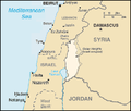 PNG
PNG

Article(s): w:Golan Heights
- Request
- Hello, could someone please vectorize this map of the Golan Heights? Thanks. --Yovt (talk) 23:00, 11 March 2026 (UTC)
- Graphist opinion(s)
Is it possible right now to add the central region onto a map?
[edit]-
 What I would like to change
 -
 What I would like for you to take inspiration from


Article(s): Subdivisions of Ethiopia
- Request
- Heya! I was wondering if it possible to add in the border of the central region (first image) with references coming from the second image. --GuesanLoyalist (talk) 08:51, 18 March 2026 (UTC)
- Graphist opinion(s)
Help optimizing code of Election map
[edit]-
 Map I need help with
 -
 Map I fixed myself


Article(s): en:1788–89 United States presidential election
- Request
- A little while back I uploaded two election maps for the 1788-1789 and 1792 US presidential election show how electors cast there second vote as at this time each elector had two vote and all electors cast one for George Washington in both elections however I made these images in a pretty crappy SVG editor so they came out with some inconsistency with other united state election maps. more recently I taught myself how to edit the code of SVGs and I optimized the the 1792 map to be more consistent but the 1788-1789 map is far more complicated and different from other election maps so I don't think I can do the same with it due to my inexperience, so I would like a more experienced Graphist to do it instead PharaohCrab (talk) 18:53, 21 March 2026 (UTC)
- Graphist opinion(s)
Update NUTS maps
[edit]-
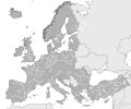 NUTS 1 regions of Europe
 -
 NUTS 2 regions of Europe
 -
.svg/120px-NUTS_3_region_(2017).svg.png) NUTS 3 regions of Europe
NUTS 3 regions of Europe


.svg)
Article(s): Nomenclature of Territorial Units for Statistics
- Request
- Our svg maps for the Nomenclature of Territorial Units for Statistics (NUTS) regions of Europe need updating, as to include new candidate countries for EU membership. Specifically, the NUTS regions for Moldova, Serbia and Ukraine need to be added (details on each are included in the linked articles). A couple details in the NUTS 2 map also need fixing, as the shading for Norway is broken and the shading for the Caspian sea is different than other seas and oceans. I tried asking about this in the file talk page, but haven't received responses, so wanted to ask the workshop about updating it. Thanks in advance. --Grnrchst (talk) 13:35, 3 April 2026 (UTC)
- Graphist opinion(s)
ChatGPT accessibility map inaccurate?
[edit]-
 Countries where ChatGPT is available

Article(s): en:ChatGPT
- Request
- This map doesn't seem right. The Channel Islands are shown as not having access to ChatGPT. Could someone verify this? --Lizardcreator (talk) 01:46, 18 April 2026 (UTC)
- Also Greenland is missing. Yann (talk) 11:04, 18 April 2026 (UTC)
- Graphist opinion(s)
- There's a few omissions of smaller territories, including the Channel Islands, which are not listed in the source list. That said, weirdly there were a number of territories that are listed there that weren't on the map, which I have added. If ChatGPT is freely available in the Channel Islands, Curacao, the Marshall Islands, and other remaining areas, it may be better to hide their circles rather than imply they are separately listed. CMD (talk) 11:10, 18 April 2026 (UTC)
Romani flag maps - Hungary
[edit]-
 This can be used in the creation of both files.
 -
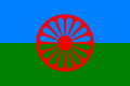 Standard Romani flag, which could be used in the creation of the first file.
 -
 Hungarian Romani flag (eight-spoked wheel), which could be used in the creation of the second file.
 -
.svg/120px-Flag-map_of_Bulgaria_(Romani_people).svg.png) Romani flag map for Bulgaria, provided as an example.
Romani flag map for Bulgaria, provided as an example. -
.svg/120px-Flag_map_of_Romania_(Roma_people).svg.png) Romani flag map for Romania, also as an example.
Romani flag map for Romania, also as an example.


.svg)
.svg)
Article(s): Anywhere where flag maps may be relevant.
- Request
- Could someone please create two new SVG flag maps representing the Romani people in Hungary, with the first one depicting the standard Romani flag and the second one depicting the unique eight-spoked wheel variant of the flag used by Hungarian Romanies? Thanks. Snow Lion Fenian (talk) 14:17, 18 April 2026 (UTC)
- Graphist opinion(s)
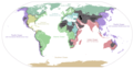
American bases worldwide
[edit]-
 Map of countries with US military bases

Article(s): en:List of American military installations
- Request
- Per the discussions here and the explanations here, I'd be grateful if someone could un-shade Iceland, Norway, Estonia and Latvia. Egypt should be un-shaded too, as that's a peacekeeping mission. I also think the rest of the world should be a darker shade of grey, as it's hard to see. Thanks. --Asarlaí (talk) 13:55, 21 April 2026 (UTC)
- Graphist opinion(s)
Iceland: path8969–path9065
 Norway: path9067–path9153
Estonia: path5944–path5970
 Latvia: lt
  Egypt: eg
- @Asarlaí:
 Done
Done - Note: previous edits messed up the grouping of SVG elements.
- For reference, here are the ids of the affected countries.
- cmɢʟee ⋅τaʟκ 09:22, 22 April 2026 (UTC)
I need a map showing location of Czechoslovakia and Hungary
[edit]-
 Location of Hungary to take from here
 -
 Location of Czechoslovakia to take from here


.png)
.svg)
.svg)
Article(s): uk:Угорсько-чехословацькі відносини (1945—1992)
- Request
- pls help me make Czechoslovakia-Hungary locator map as modelled on Czech Republic-Hungary locator map--Slovolyub (talk) 16:49, 22 April 2026 (UTC)
- Graphist opinion(s)